Using AI and Data Annotation to Fight Wildfires
Category: AI Insights
Published date: 24.09.2021
Read time: 5 min
Since 1983, the National Interagency Fire Center has documented an average of approximately 70,000 wildfires per year. In addition to all of the damage caused to forests and wildlife, wildfires take a heavy toll on our society as well. They cause a lot of deaths, mental trauma, and damage to personal property. Even people who managed to save themselves from the fires are always wondering about the state of their homes. Researchers at Stanford University have created new AI technology that shows people whether or not their property was damaged by the fires. Let’s take a closer look at this new application and the data annotation that was used to create it.
What is the Damage Map and How Does It Work?
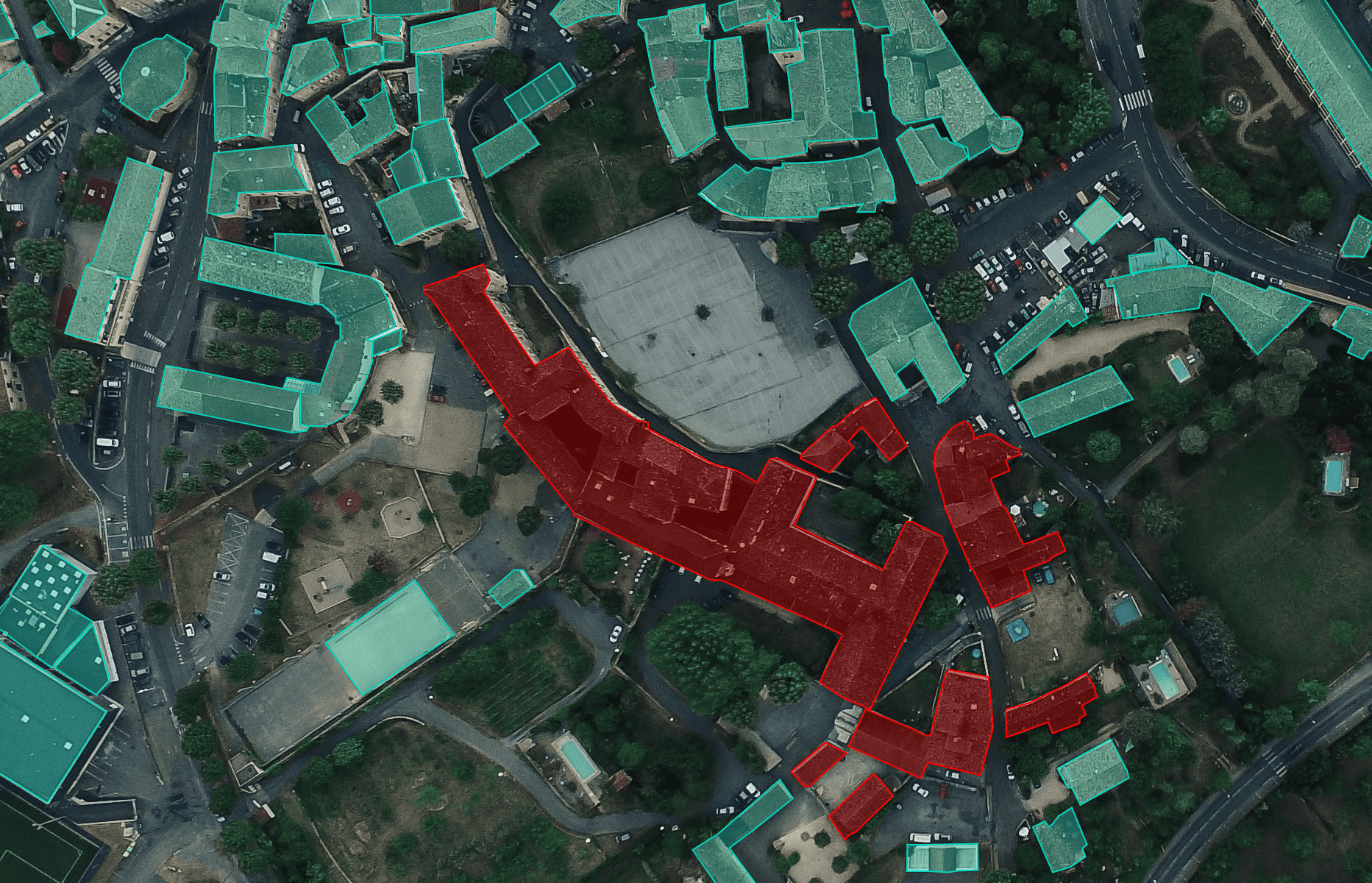
Damage Map is an AI application developed by research teams from Stanford and California Polytechnic State University. The system relies on various satellite, aerial, and drone photographs to identify damaged homes and buildings with 92% accuracy. It first uses all sorts of pre-fire photos to map the area and locate the building. The program then analyzes the images after the wildfire to identify damage due to features such as blackened surfaces, collapsed roofs, and lack of structures.
The new system allows first responders and other relevant parties to scan an entire town in a matter of hours and provide officials with more information to improve the decision-making process of firefighters and emergency responders, and fire damage by filing insurance claims and obtaining information to help bring life back on track.
What Impact Could the Damage Map Have?
The Damage Map could replace current methods of assessing fire damage which requires people to go door-to-door and check all of the buildings. At this stage, the system is only able to determine whether or not there is fire damage, but it cannot go a step further and classify the damage into categories such as little damage, minor damage, major damage, or destruction. This could be a goal for future development work, but the system can significantly reduce the time people have to wait to find out what happened to their homes.
People around the world are suffering from the nerve-wracking anxiety of waiting weeks or months to find out if a home has been damaged by an intensifying wildfire. When the smoke disappears and aerial photography is possible, researchers will now be able to identify damage to the building within minutes.
What Types of Data Annotation Was Necessary to Create the Damage Map
In order to understand which data annotation methods were used, we first need to know how the system analyzes the aerial images it receives. DamageMap uses all types of photos taken before the fire to map the area and locate building locations. The program then analyzes the images after a forest fire to identify damage from features such as blackened surfaces, destroyed roofs, or the lack of structures. The raw dataset also included damage data collected on-site by California Department of Forestry and Fire Protection (CAL FIRE) agents. Basically, damage inspectors went through painstaking efforts going door to door, looking at the damage, geotagging locations and finally making it publicly accessible.
Human data annotators would need to take this raw dataset and label it either with simple tagging or 2D box annotation. Also, they would need to use semantic segmentation to show blackened surfaces, destroyed roofs, and other things the system would need to identify. Quality data annotation will also be critical if researchers need the system to classify the damage into the categories we mentioned earlier, but more raw datasets will need to be made available as well.
Mindy Support Provides Comprehensive Data Annotation Services
Regardless of the volume of data, you need to be annotated or the complexity of your project, Mindy Support will be able to assemble a team for you to actualize your project and meet deadlines. We are the largest data annotation company in Eastern Europe with more than 2,000 employees in six locations all over Ukraine and in other geographies globally. Our size and location allow us to source and recruit the needed number of candidates within a short time frame and we can scale your team without sacrificing the quality of the work provided. Contact us today to learn more about how we can help you.


