Unlocking the Physical World for AI with LiDAR
Published date: 27.03.2024
Read time: 13 min
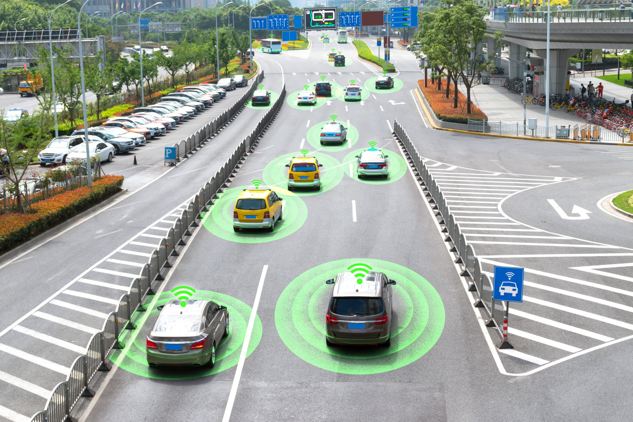
In the realm of cutting-edge technology, LiDAR stands out as a pioneering force, transforming the way we perceive and interact with our environment. From archaeology to autonomous vehicles, LiDAR’s applications are vast and diverse, revolutionizing industries and unlocking new possibilities. In this article, we will take a look at what exactly is LiDAR, and how it works, as well as the data annotation needed to train AI systems.
What is LiDAR?
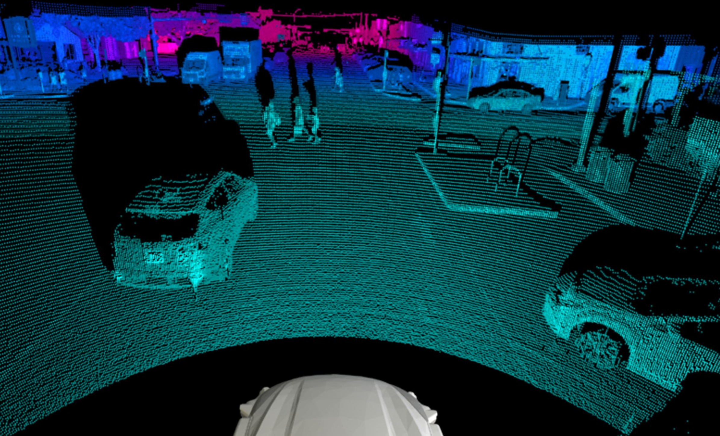
LiDAR, an acronym for Light Detection and Ranging, is a remote sensing method that employs light in the form of a pulsed laser to measure variable distances to the Earth. It operates on a simple principle: measuring the time it takes for a laser pulse to travel from the sensor to an object and back, thus determining its distance. This process is akin to how radar uses radio waves but with the speed of light.
How Do You Collect LiDAR Data?
Collecting LiDAR data involves a meticulous process that begins with the careful planning of the survey area and the selection of appropriate flight parameters. Typically, LiDAR data collection is conducted using airborne or ground-based platforms equipped with LiDAR sensors. For airborne LiDAR, an aircraft equipped with the necessary instrumentation flies over the target area in a systematic pattern, emitting laser pulses toward the ground. The sensor records the time taken for the pulses to return, capturing millions of data points per second. Ground-based LiDAR systems, on the other hand, are stationary or mobile units positioned at vantage points to scan the surrounding environment.
Regardless of the platform used, precise positioning and orientation are essential, often achieved through the integration of GPS and IMU technologies. Additionally, weather conditions, such as cloud cover and wind speed, must be considered to ensure optimal data quality. Once collected, the raw LiDAR data undergoes processing to generate accurate three-dimensional point clouds, which can then be utilized for various applications, ranging from urban planning to environmental monitoring.
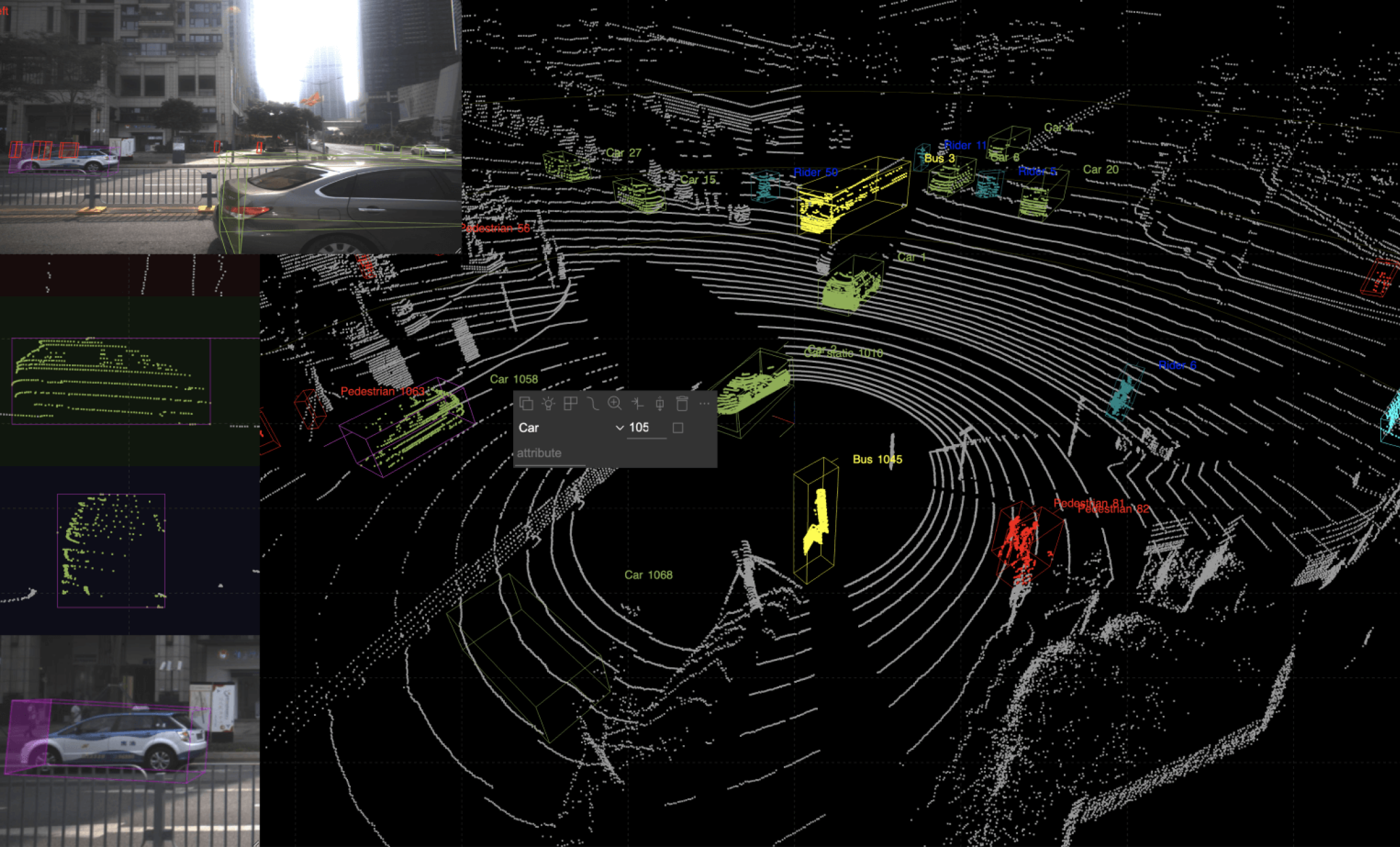
Different types of LiDAR Annotation
LiDAR annotation involves labeling or annotating the data points within a LiDAR point cloud to provide context and meaning for various applications. Here are some common types of LiDAR annotation:
- Point-level annotation – Point-level annotation refers to the process of annotating individual points within a LiDAR point cloud with specific attributes or labels. In LiDAR data, each point represents a discrete measurement of the environment, typically consisting of three-dimensional coordinates (x, y, z) and additional attributes such as intensity or color.
- Bounding box annotation – This is a technique used in computer vision and image processing to identify and outline the location of objects within an image or scene. It involves drawing a rectangle (or bounding box) around the object of interest to indicate its spatial extent and location within the image.
- Semantic segmentation – Semantic segmentation annotation involves labeling each point in the LiDAR point cloud with a semantic class, such as road, sidewalk, vegetation, or building. Semantic segmentation provides a detailed understanding of the scene’s layout and composition, facilitating tasks like urban planning, environmental monitoring, and infrastructure development.
- Instance segmentation – Similar to semantic segmentation, instance segmentation annotation involves labeling each point with both a semantic class and an instance ID. This allows for the differentiation of individual objects of the same class, such as differentiating between multiple vehicles or trees within the point cloud.
Challenges in LiDAR Annotation
LiDAR annotation, although essential for various applications, presents several challenges due to the complexity of LiDAR data and the diverse requirements of different tasks. Some of the main challenges in LiDAR annotation include:
- Data Volume – LiDAR point clouds can contain millions or even billions of points, leading to massive data volumes that require substantial computational resources and time to annotate manually.
- Sparse and Irregular Point Distribution – LiDAR point clouds often exhibit non-uniform point density and irregular distribution, making it challenging to ensure consistent annotation quality across the entire dataset.
- Complexity of 3D Objects – Annotating three-dimensional objects within LiDAR point clouds, such as buildings, trees, or vehicles, requires accurately defining their boundaries and spatial extent in three-dimensional space, which can be challenging and time-consuming.
- Object Occlusion – Objects within LiDAR point clouds may be partially or fully occluded by other objects or terrain, making it difficult to annotate them accurately without a comprehensive understanding of the scene geometry.
- Semantic Understanding – Assigning meaningful semantic labels to points or objects within the LiDAR data requires domain expertise and contextual understanding of the scene, which may vary depending on the application and environment.
Best Practices for LiDAR Annotation
Best practices for LiDAR annotation are crucial for ensuring accuracy, consistency, and efficiency in the annotation process, ultimately leading to high-quality annotated datasets. Here are some key best practices:
- Understand the Application: Before starting the annotation process, it’s essential to have a clear understanding of the specific application and requirements of the LiDAR data. This includes understanding the types of objects or features to be annotated and the level of detail needed for analysis.
- Develop Annotation Guidelines: Establish clear and comprehensive annotation guidelines that define the annotation tasks, labeling conventions, object classes, and quality standards. Annotation guidelines help ensure consistency among annotators and across different annotation sessions.
- Use Specialized Software: Utilize specialized annotation software or tools designed for LiDAR data annotation, which offer features such as point cloud visualization, 3D object labeling, and efficient annotation workflows. These tools streamline the annotation process and enhance productivity.
- Quality Control: Implement quality control measures throughout the annotation process to detect and correct errors or inconsistencies. This may include regular reviews of annotated data, inter-annotator agreement checks, and validation against ground truth or reference data.
- Iterative Refinement: Annotation is often an iterative process, especially for complex or large-scale datasets. Allow for iterative refinement of annotations based on feedback, validation results, or additional insights gained during the annotation process.
Tools and Techniques for LiDAR Annotation
Annotation of LiDAR data involves specialized tools and techniques designed to handle the unique characteristics of three-dimensional point clouds. Here are some commonly used tools and techniques for LiDAR annotation:
LiDAR Annotation Software:
- CloudCompare: A popular open-source software for processing and annotating LiDAR point clouds. It offers various visualization and editing tools for annotating objects and features within the point cloud.
- Terrasolid: A commercial software suite designed specifically for LiDAR data processing, including classification, feature extraction, and annotation.
- LASTools: A collection of command-line tools for LiDAR data processing, including point cloud classification, segmentation, and annotation tasks.
- Potree: A web-based viewer for visualizing and annotating LiDAR point clouds in a browser environment. It supports basic annotation capabilities for labeling objects within the point cloud.
Semi-Automated Annotation Techniques:
- Machine Learning-Based Classification: Utilize machine learning algorithms, such as random forests or convolutional neural networks (CNNs), to automatically classify points within the LiDAR point cloud into different object classes. Semi-automated approaches can significantly reduce manual annotation effort.
- 3D Object Detection: Apply 3D object detection algorithms to automatically detect and localize objects within the LiDAR point cloud, followed by manual refinement or verification of detected objects.
Manual Annotation Techniques:
- Point Classification: Manually assign class labels to individual points within the LiDAR point cloud based on their characteristics (e.g., ground, vegetation, buildings). This may involve visually inspecting the point cloud and assigning labels using annotation software.
- Bounding Box Annotation: Manually draw bounding boxes around objects of interest within the LiDAR point cloud to delineate their spatial extent and location. Bounding box annotation is commonly used for object detection and localization tasks.
- 3D Polyline Annotation: Define 3D polyline or polygonal shapes to annotate linear or planar features within the LiDAR point cloud, such as road edges, building outlines, or tree crowns.
Future Trends in LiDAR Annotation
The field of LiDAR annotation is evolving rapidly, driven by advancements in technology, machine learning, and the increasing demand for annotated LiDAR datasets in various industries. Several future trends are expected to shape the landscape of LiDAR annotation:
- Automation and AI-Assisted Annotation: One of the most significant trends in LiDAR annotation is the increasing adoption of automation and AI-assisted annotation techniques. Machine learning algorithms, particularly deep learning models such as convolutional neural networks (CNNs), are being leveraged to automate tasks such as point cloud classification, object detection, and semantic segmentation. These AI-assisted techniques can significantly reduce the manual effort required for annotation and improve efficiency.
- Semi-Supervised and Active Learning Approaches: Semi-supervised learning and active learning techniques are gaining traction in LiDAR annotation. These approaches leverage a small amount of labeled data combined with unlabeled or partially labeled data to train machine learning models more effectively. Active learning algorithms select the most informative data points for annotation, allowing annotators to focus on the most critical areas of the LiDAR point cloud.
- Multi-Modal Data Fusion: Future trends in LiDAR annotation involve the integration of LiDAR data with other sensor modalities, such as imagery, radar, or thermal sensors. Multi-modal data fusion enables more comprehensive and context-rich annotation, leading to improved understanding and analysis of the environment. Annotation tools and techniques capable of handling multi-modal data will become increasingly important.
Choosing a LiDAR Annotation Partner
Choosing the right LiDAR annotation partner is crucial for ensuring the quality, accuracy, and efficiency of the annotation process. Here are some factors to consider when selecting a LiDAR annotation partner:
- Expertise and Experience: Look for a partner with expertise and experience in LiDAR data annotation. Consider factors such as the partner’s track record, years of experience in LiDAR annotation, and the qualifications of their team, including domain knowledge and technical skills.
- Quality Assurance Processes: Evaluate the partner’s quality assurance processes and procedures to ensure the accuracy and reliability of annotated LiDAR datasets. Ask about their quality control measures, validation techniques, and adherence to industry standards and best practices.
- Annotation Tools and Technologies: Assess the partner’s annotation tools and technologies for handling LiDAR data annotation. Look for partners that use specialized software tools, automation techniques, and machine learning algorithms to streamline the annotation process and improve efficiency.
- Scalability and Capacity: Consider the partner’s scalability and capacity to handle large-scale annotation projects. Ensure that they have the resources, infrastructure, and workforce necessary to scale up or down according to your project requirements.
- Data Security and Confidentiality: Prioritize partners that prioritize data security and confidentiality. Ensure that they have robust data protection measures in place, including secure data handling practices, compliance with privacy regulations, and confidentiality agreements.
Final Thoughts
As LiDAR technology continues to evolve, its capabilities are expected to expand even further. Advancements in miniaturization, cost reduction, and integration with other sensing technologies hold the promise of making LiDAR more accessible and versatile than ever before. From enhancing safety on our roads to unraveling the mysteries of the past, LiDAR stands at the forefront of innovation, shaping the way we perceive and interact with the world around us.