Precision Unleashed: Optimizing Geospatial Annotation Accuracy
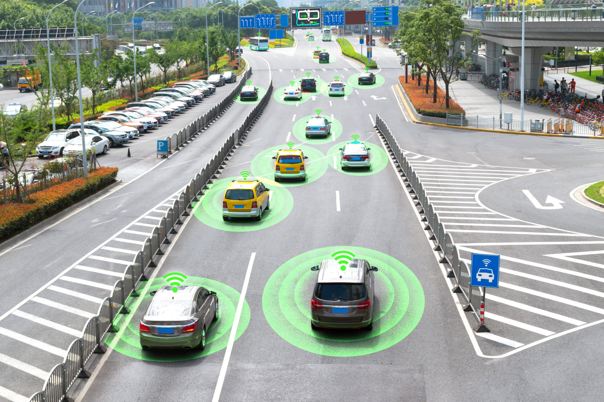
Geospatial annotations refer to the process of tagging digital maps with metadata information. This information often includes details about geographic locations, descriptions of physical boundaries, and annotations about the attributes of specific places. As the demand for accurate and detailed geospatial data grows across various sectors—including urban planning, environmental monitoring, logistics, and more—ensuring the accuracy of geospatial annotations has become increasingly important. Here, we explore best practices for improving the accuracy of these annotations, which is vital for making informed decisions based on geospatial data.
Common Geospatial Data Annotation Techniques and Examples
A number of data annotation techniques are used for geospatial data annotation. These include:
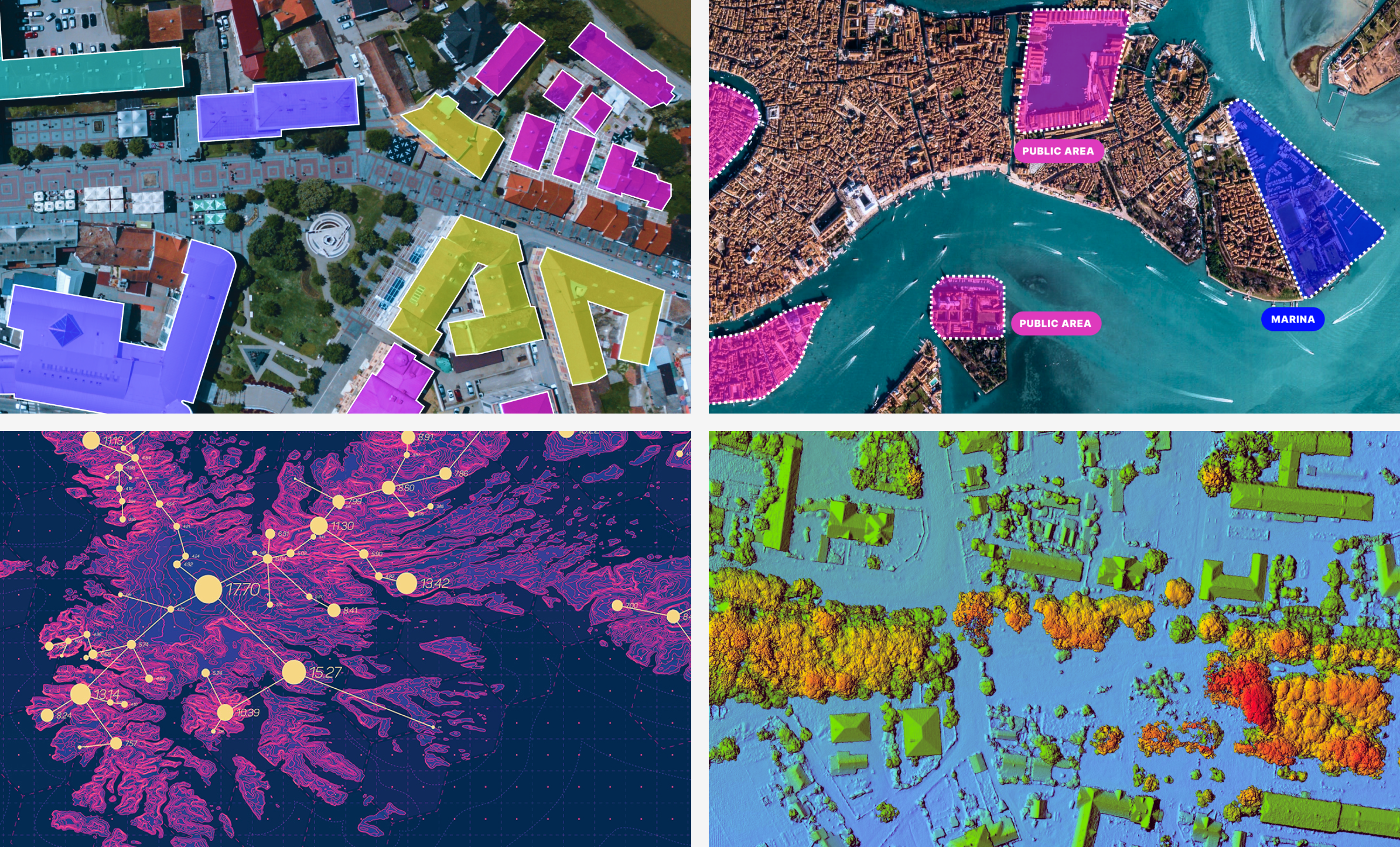
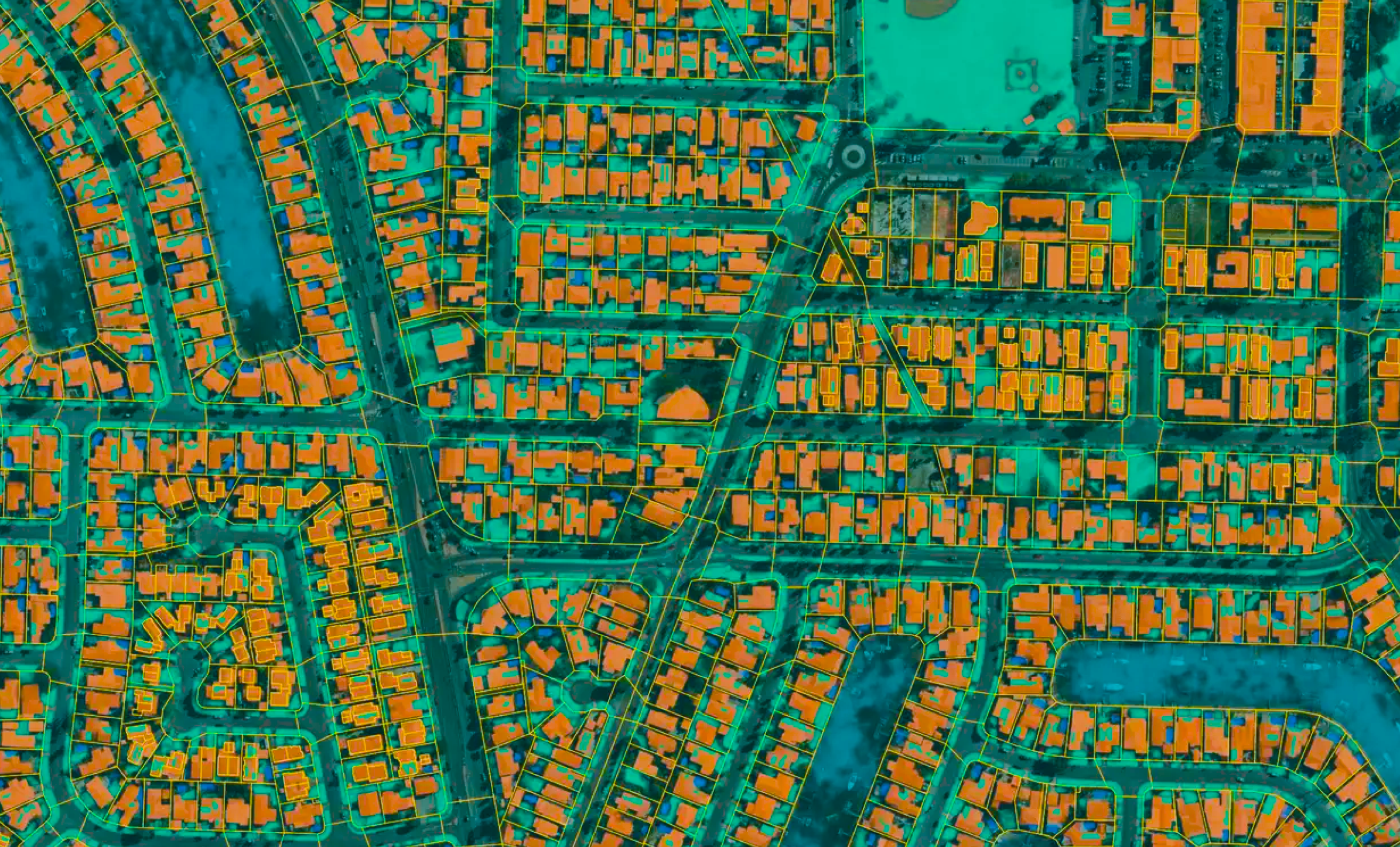
- Semantic segmentation – Semantic segmentation plays a crucial role in geospatial annotation by classifying each pixel in an image into predefined categories, thereby enabling a more detailed and accurate representation of geographic features. This technique is instrumental in distinguishing between different land cover types, such as buildings, roads, vegetation, and water bodies, in satellite imagery or aerial photographs, greatly enhancing the precision and utility of geospatial datasets for analysis and decision-making in urban planning, environmental conservation, and disaster management.
- Polygon annotation – Polygon annotation in geospatial annotation involves drawing precise polygonal shapes around specific features of interest in satellite imagery or aerial photographs to delineate boundaries and classify land use accurately. This method is crucial for tasks requiring high levels of detail and accuracy, such as mapping agricultural fields, urban development zones, or protected natural areas, enabling analysts and decision-makers to understand spatial relationships and manage resources more effectively.
- LiDAR annotation – This technique leverages the depth information provided by LiDAR technology to create highly accurate 3D models of the Earth’s surface and its features. This process is essential for mapping complex environments with precision, including forest canopies, urban infrastructure, and terrain contours, offering invaluable insights for city planning, environmental monitoring, and autonomous vehicle navigation by providing detailed spatial relationships and object classifications.
- Keypoint annotation – Keypoint annotation for geospatial annotation involves identifying and marking specific points of interest or landmarks within an image, such as building corners, bridge joints, or the peak of a mountain. This method is particularly useful for detailed analysis and monitoring of structural integrity, urban development, and geological features, enabling precise measurements and tracking changes over time in the geospatial domain.
Advanced Technologies in Geospatial Annotation
As you may imagine, geospatial annotation requires the use of certain advanced technologies. This includes things like:
- 3D modeling and annotation – 3D modeling and annotation in geospatial data involve creating detailed three-dimensional representations of geographic areas, incorporating annotations that provide additional context, such as the height of buildings, the type of vegetation, or the classification of terrain. This approach significantly enhances the analysis and visualization capabilities for urban planning, disaster management, and environmental studies, offering a more immersive and comprehensive understanding of spatial dynamics and relationships in both natural and built environments.
- Satellite imagery analysis and annotation – Satellite imagery analysis and annotation involve the process of examining and labeling satellite images to identify and categorize various geographical features and phenomena. This practice is crucial for a wide range of applications, including environmental monitoring, urban planning, and disaster response. By annotating satellite imagery, researchers and analysts can track changes over time, assess the Impact of natural or human-made events, and gain insights into the condition and use of land and natural resources, facilitating informed decision-making and strategic planning.
- Integration of AI and machine learning in geospatial annotation – The integration of AI and machine learning in geospatial annotation revolutionizes the efficiency and accuracy of annotating vast amounts of geographic data. By leveraging algorithms capable of recognizing patterns and features within satellite imagery or maps, AI-powered systems can automate the annotation process, reducing the time and resources required for manual annotation while improving consistency and scalability. This synergy empowers organizations across sectors such as agriculture, urban planning, and disaster management to extract valuable insights from geospatial data at an unprecedented scale, facilitating smarter decision-making and enhancing our understanding of the world around us.
Scaling Geospatial Data Labeling
Machine learning projects involving geospatial data may require you to scale your efforts. The information below will be useful when you need to scale your geospatial data labeling:
- Strategies for efficient data management and annotation at scale – One thing you can do is develop automated pipelines leveraging AI and machine learning algorithms to annotate large volumes of data quickly and accurately. Also, it is a good idea to implement parallel annotation workflows, where multiple annotators work simultaneously on different sections of the dataset.
- Active learning and its Impact on scalability and efficiency – Active learning is a machine learning approach where the algorithm selects the most informative data points from an unlabeled dataset for annotation by human annotators. The Impact of active learning on scalability and efficiency is significant. By actively selecting the most informative samples for annotation, active learning reduces the annotation burden on human annotators, allowing them to focus their efforts on labeling data points that are most valuable for improving the model’s performance.
- Custom object detection models – Several custom object detection models have been developed to address specific requirements and challenges in various domains. For example, there is Faster R-CNN, which is a widely used object detection framework that utilizes a region proposal network (RPN) to generate potential bounding box proposals. These proposals are then refined using convolutional layers to classify objects and predict accurate bounding box coordinates.
- Segment Anything Model (SAM) – This is a model or technique designed to address the segmentation of diverse and possibly arbitrary objects or regions within an image without being restricted to specific classes or categories. Such a model aims to provide a more generalized and versatile approach to segmentation tasks, potentially by leveraging techniques from weakly supervised learning, domain adaptation, or transfer learning.
How to Label Geospatial Data
Labeling geospatial data involves assigning categorical or numerical attributes to specific geographic locations or features, facilitating the interpretation and analysis of spatial information. Accurate labeling is crucial for training machine learning models in tasks such as land cover classification, object detection, or spatial prediction, ensuring the reliability and effectiveness of geospatial analyses and applications. Below, we talk about some techniques for labeling geospatial data:
- Active learning – Active learning in the context of geospatial data involves iteratively selecting the most informative data points to label or analyze, thereby optimizing the learning process for machine learning algorithms. By intelligently choosing which data to annotate or examine further, active learning techniques enhance the efficiency and accuracy of geospatial analyses, enabling more precise insights into spatial patterns and phenomena.
- Custom object detection models – Geospatial data, encompassing imagery from satellites, drones, and ground-based sensors, holds intricate spatial information crucial for various applications. Custom object detection models, powered by deep learning algorithms, enhance geospatial analysis by automating the detection and classification of specific objects within imagery, enabling more efficient and accurate insights for tasks.
- Segment Anything Model (SAM) – Geospatial data presents a rich tapestry of Earth’s surface, comprising imagery captured through satellites, drones, and ground-based sensors. Segment Anything Model, a cutting-edge deep learning framework, specializes in segmenting diverse objects within geospatial imagery, offering unparalleled accuracy and versatility in tasks such as land cover classification, infrastructure monitoring, and environmental analysis.
- Label large spatial datasets 10x faster – Labeling large geospatial datasets 10 times faster is now achievable through innovative automation tools and collaborative platforms. Leveraging advanced machine learning algorithms and distributed labeling workflows, analysts can efficiently annotate vast amounts of spatial data, accelerating the process of training custom object detection models and enabling quicker insights for various applications such as urban planning, environmental monitoring, and disaster response.
How to Ensure Geospatial Annotation Accuracy
Maintaining the needed accuracy level is one of the most important aspects of geospatial data annotation. Here are some tips on how you can reach the needed quality levels:
- Enable transparent review and feedback – Geospatial labeling processes need to facilitate transparent review and feedback mechanisms, empowering stakeholders to provide input and verify accuracy. Through collaborative platforms and annotation tools, users can easily review labeled geospatial data, ensuring alignment with project requirements and enhancing the reliability of datasets for subsequent analyses and model training.
- Leverage quality metrics and analytics – Geospatial annotation practices are evolving to incorporate quality metrics and analytics, enabling more informed decision-making throughout the annotation process. By leveraging metrics such as annotation consistency, coverage, and accuracy, stakeholders can assess the reliability of annotated geospatial data, optimize annotation workflows, and enhance the overall quality of datasets for downstream analyses and model training in applications ranging from urban planning to natural resource management.
- Automate quality assurance (QA) workflow – Automating the quality assurance workflow for geospatial annotation streamlines the process of verifying and validating labeled data at scale. By implementing machine learning algorithms and automated checks, such as comparing annotations against ground truth data or detecting inconsistencies, organizations can ensure the accuracy and reliability of annotated geospatial datasets more efficiently, facilitating the seamless integration of high-quality data into downstream analyses and applications.
- Automated QA based on the model likelihood – Automated quality assurance based on the model likelihood in geospatial annotation employs machine learning algorithms to assess the confidence levels of model predictions. By analyzing the likelihood scores assigned to annotations, organizations can prioritize reviewing instances where the model exhibits lower confidence, improving the overall accuracy and reliability of labeled geospatial datasets while optimizing resource allocation in the QA process.
- Programmatic QA – Programmatic QA in geospatial annotation involves developing automated processes to systematically assess the quality of annotated data. By implementing algorithms and scripts to detect errors, inconsistencies, or anomalies within the annotations, organizations can ensure the accuracy and reliability of geospatial datasets more efficiently, reducing the need for manual review and enabling faster iteration cycles in annotation workflows.
- Double Your Labeling Productivity with Programmatic QA – Double Your Labeling Productivity with Programmatic QA in geospatial annotation by automating error detection and correction processes. By utilizing algorithms and scripts to systematically review annotations, organizations can significantly increase labeling efficiency while maintaining data accuracy and reliability, ultimately expediting the development of machine learning models and enhancing decision-making in geospatial applications.
Conclusion
Improving the accuracy of geospatial annotations requires a multifaceted approach that includes the use of high-quality base maps, advanced tools, rigorous quality control, and, increasingly, the integration of machine learning. By adopting these best practices, organizations can enhance the reliability of their geospatial data, leading to better-informed decision-making across a wide range of applications.