Geospatial Data Annotation for AI & ML
Images from satellites contain a lot of important information that can be used to train AI and ML systems. However, in order for that data to be usable, it needs to be prepared with various data annotation techniques. In this article, we will take a look at geospatial data annotation to understand not only what it is but also understand the value it can bring to companies across industries.
What is Geospatial Annotation?
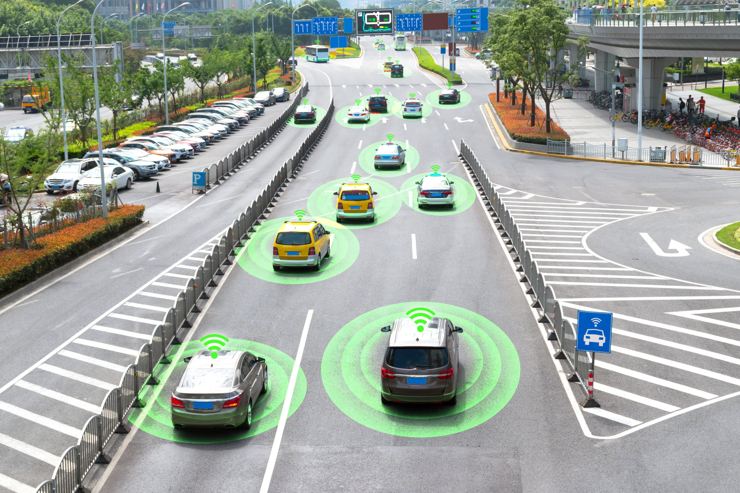
Geospatial annotation incorporates suitable satellite and aerial imagery into datasets that are compatible with AI and machines. This results in an internal real-time dataset that can be used to evaluate and give companies crucial actionable data. A few examples of frequently annotated geospatial imagery include mapping large farms, building sites, mines, real estate developments, catastrophe recovery situations, and geographical features. In the context of algorithms that enable effective access and retrieval of images from sizable geospatial datasets, geospatial annotation serves as a priceless supply of input data for machine learning tools.
Now that we received a brief overview of geospatial annotation let’s dive deeper to learn about some of the geospatial data annotation techniques.
Types of Geospatial Data Annotation Techniques
While the type of data annotation will depend on the project requirements and the functionality of the AI/ML system, below are some of the most common types:
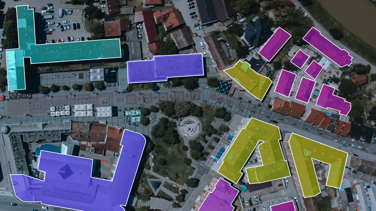
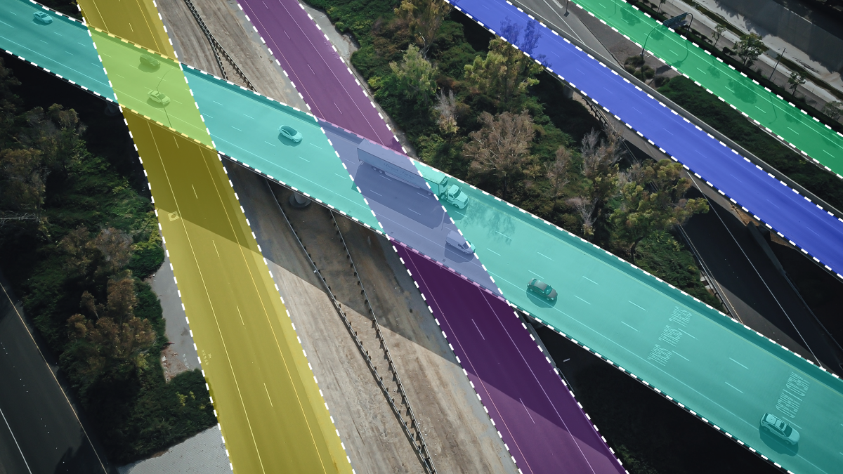
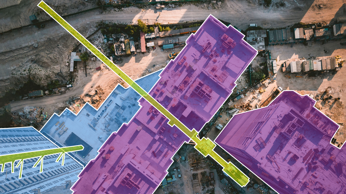
- Semantic Segmentation – Semantic segmentation is a deep learning algorithm that associates a label or category with every pixel in an image. It is used to recognize a collection of pixels that form distinct categories.
- Polygon annotation – Polygon annotation is a precise method of annotating where a collection of coordinates are drawn around an image. These coordinates are meant to surround a specific object in an image closely.
- LiDAR annotation – This involves labeling the objects in the scene, such as cars, pedestrians, and traffic signs. Lidar heavily relies on machine learning models to provide real-time interpretations of point cloud data.
- Keypoint annotation – Keypoint annotation is a more detailed protocol of image annotation used to detect small objects and shape variations by marking the locations of key points. Keypoint annotations are used to label a single pixel in the image to portray an object’s shape.
Geospatial Data Annotation Techniques
Satellite images contain huge repositories of geospatial information. The following data annotation techniques are used to make use of this data to train AI/ML algorithms:
- Geotagging – Geotagging is the process of adding metadata to a digital map that includes geographic data about a location. Latitude and longitude coordinates make up the majority of the data, but it may also include a timestamp and connections to other resources.
- Place name recognition – Place name recognition is the delimitation of character strings that relate to place names in unstructured text. This is an example of the more widespread Named Entity Recognition (NER) issue, which has received a great deal of attention in the Natural Language Processing (NLP) field.
- Land use classification – On your comprehensive plan map or another document, you refer to the various wanted or planned categories of future land uses as land use classifications. Residential, business, and industrial are the three traditional broad categories, and the terms can get more specific from there.
- Route annotation – This process involves annotating all of the various routes that can be taken to get from one point to another. This allows the AI system to better calculate the most optimal route.
- Point of interest annotation – Point of interest (POI) annotation refers to the processes of pattern recognition (namely clustering), extraction, and semantic annotation.
Which Industries Can Benefit From Geospatial Annotation?
Geospatial data annotation can be used to train AI/ML systems to benefit the following industries:

Agriculture – Farmers can utilize precision agriculture to the use of data and data analytics to develop more efficient farming techniques that reduce costs for everything from irrigation to the use of fertilizers, pesticides, and herbicides through “as-needed” models heavily reliant on geospatial data. Aerial images of agricultural fields captured by drones need to be annotated using semantic segmentation and other techniques.
Construction – AI companies are working on improving the efficiency of the construction processes, from planning to monitoring during actual construction. Enhancing the safety of human workers in construction sites using AI is starting to gain prominence among most large construction firms. Geospatial annotation is needed to analyze and label spatial data like satellite images and visual GPS data.
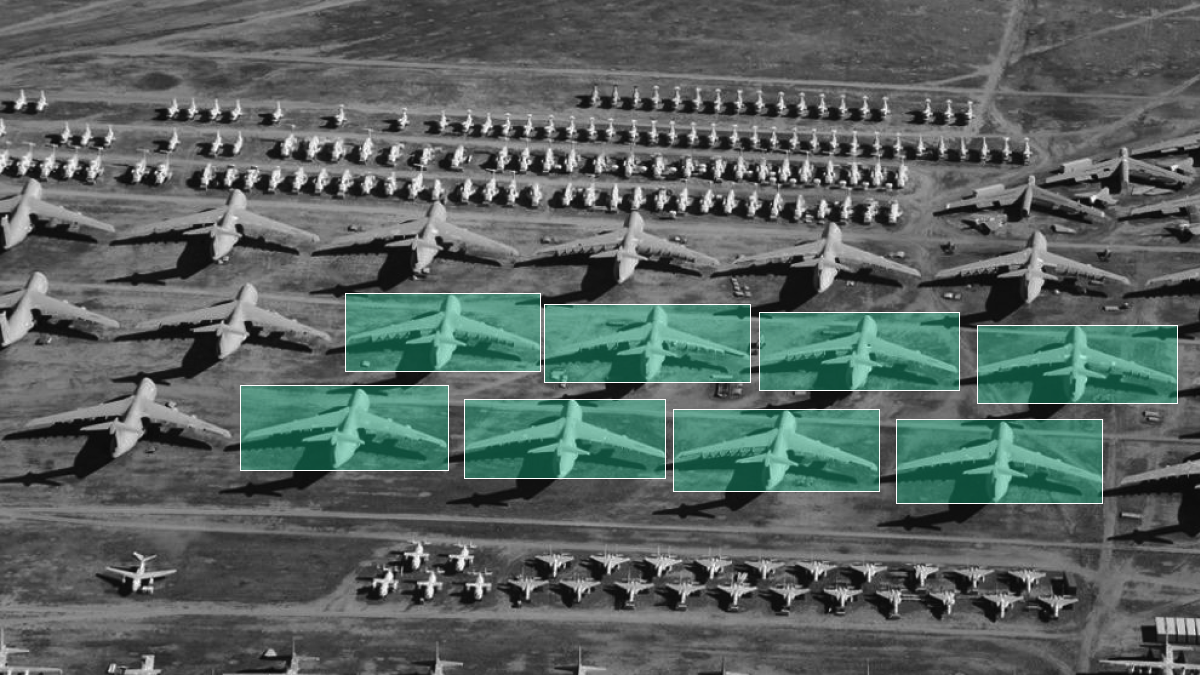
Aerospace & Defense – Geospatial annotation can be useful for threat and activity detection and transforming aerial videos and images into Geospatial 3D models. Highly accurate object detection will be needed to make sure the system identifies all of the various information.
Logistics – Companies operating in the logistics industry can use geospatial data annotation to create AI technology that plans the most optimal routes. This would require polyline annotation to make sure the system identifies even the smallest roads that can shorten distances.
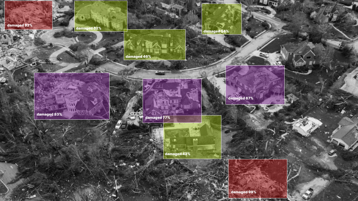
Disaster management – Geospatial annotation can be used to map areas affected by natural disasters, such as earthquakes, hurricanes, tsunamis, and floods, in order to aid in rescue and reconstruction efforts. This would require tagging and bounding box annotation since there are almost limitless possibilities in terms of the scene the AI system will need to analyze.
Trust Mindy Support With All of Your Data Annotation Needs
Mindy Support is a global provider of data annotation services and is trusted by Fortune 500 and GAFAM companies. With more than ten years of experience under our belt and offices and representatives in Cyprus, Poland, Romania, Bulgaria, India, OAE, and Ukraine, Mindy Support’s team now stands strong with 2000+ professionals helping companies with their most advanced data annotation challenges.