UAV Surveillance Data Annotation & Tracking for Defense AI Systems

Company Profile
Industry: Defense Technology
Focus: UAV (Drone) Intelligence & Surveillance
Region: Europe (NATO-aligned environment)
Company Bio
A European defense technology company specializing in AI-powered UAV (drone) intelligence and surveillance systems. The company develops advanced solutions for real-time situational awareness, integrating computer vision, geospatial analytics, and aerial data processing. Its platforms are used to support mission-critical decision-making in complex operational environments.
Services
UAV video annotation (frame-by-frame), Multi-object tracking (ID persistence), Instance & pixel-level segmentation, Temporal event annotation, Geospatial & terrain labeling, Multimodal data structuring
Project Overview:

A defense technology company partnered with Mindy Support to develop a high-precision annotation pipeline for UAV (drone) surveillance data, supporting AI models used in intelligence and monitoring systems.
The project involved processing large-scale drone video streams and aerial imagery to create structured datasets for: Object detection, Multi-object tracking, Activity recognition, Geospatial analysis. The objective was to enable accurate, real-time situational awareness in operational environments.
Business Challenge
Working with UAV data in defense scenarios introduced several complexities:
- Low-visibility targets: small objects, motion blur, and camouflaged assets
- Dynamic scenes: multiple moving objects across large areas
- Temporal dependency: need to track objects consistently across frames
- Geospatial alignment: combining visual data with GPS and terrain context
- High accuracy requirements: annotation precision directly impacts model performance
Why Mindy Support
Mindy Support was selected due to its ability to deliver high-precision annotation workflows for complex visual data, combined with experience in multi-object tracking, geospatial labeling, and large-scale dataset structuring.
Key factors included:
- Proven expertise in computer vision annotation for dynamic environments
- Ability to scale dedicated teams with fast ramp-up and consistent quality
- Strong multi-layer QA processes ensuring high accuracy across sequences
- Experience working within secure, enterprise-grade data environments
- Flexibility to adapt workflows to domain-specific requirements such as UAV intelligence
Services Provided
Mindy Support designed a drone-specific annotation and data structuring workflow to transform raw UAV footage into intelligence-ready datasets.
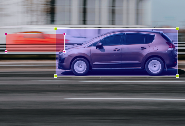
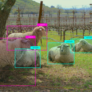
The process started with frame-by-frame video annotation, identifying vehicles, personnel, and infrastructure — including small, occluded, and low-visibility targets. This was extended with multi-object tracking, ensuring persistent IDs and accurate trajectory mapping across sequences, even in cases of occlusion.
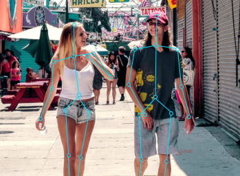
To improve precision in complex environments, we applied instance and pixel-level segmentation, enabling detailed labeling of camouflaged and partially visible objects. In parallel, temporal event annotation captured movement patterns, zone entry/exit, and behavioral activities over time.
Each annotation layer was enriched with geospatial context, linking visual data to GPS coordinates, terrain types, and strategic infrastructure. Finally, all data was unified through multimodal structuring, aligning video, metadata, and annotations into datasets optimized for detection, tracking, and behavior analysis models.
Solution
Mindy Support implemented a dedicated UAV annotation workflow, tailored to drone-based surveillance data.
The pipeline included:
- Secure data ingestion and preprocessing of UAV video streams
- Frame-level annotation combined with sequence-level tracking
- Temporal event tagging to capture behavioral patterns over time
- Geospatial alignment of annotations with real-world coordinates
- Multi-stage quality control, including senior QA validation and calibration cycles
This structured approach ensured consistency, accuracy, and scalability across large volumes of drone data.
Key Results
- Improved object detection accuracy for vehicles, personnel, and infrastructure
- Reliable multi-object tracking across UAV video sequences
- Enhanced activity recognition through temporal annotation
- Geospatially-aware datasets enabling stronger situational analysis
- Production-ready UAV datasets optimized for real-time defense AI systems
GET A QUOTE FOR YOUR PROJECT
We have a minimum threshold for starting any new project, which is 735 productive man-hours a month (equivalent to 5 graphic annotators working on the task monthly).